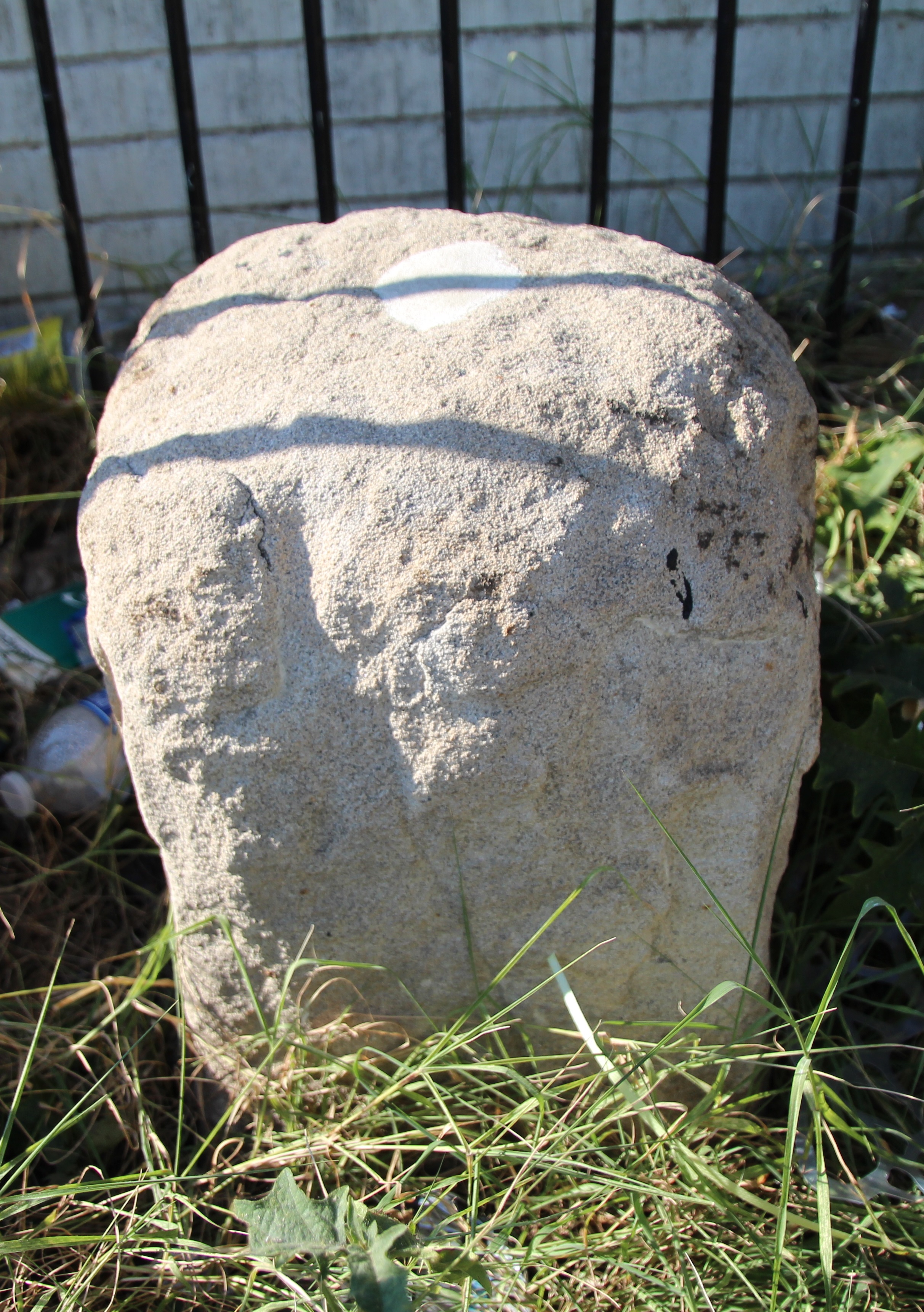
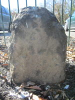
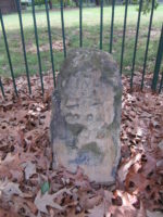
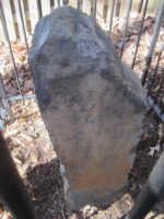
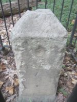
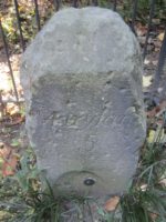
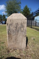
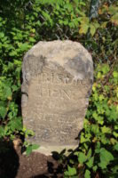
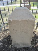
Jones Point Lighthouse, Alexandria, Virginia Jones Point Lighthouse: in an opening in the seawall of the lighthouse at Jones Point Park on the Potomac River in Alexandria, Virginia. The lighthouse was built in 1855 and a seawall was constructed in 1861. As documented by Woodward and others, the stone was hidden behind this seawall until June 1912. Because the stone remains in an enclosure in the wall, it can be difficult to view it in its entirety. According to the Records of the Columbia Historical Society (Volume 2, pp. 60-61), on March 25, 1794, the district commissioners requested that the city surveyor “have a large stone lettered ‘The beginning of the Territory of Columbia,’ prepared and fixed at the beginning of the territory, in the presence of some of the gentlemen who were present at the fixing of the small stone now there.” By June 21, 1794, this new corner stone had replaced the original ceremonial corner stone from 1791. According to Washington City and Capital, published in 1937, the original ceremonial stone was then buried beneath the fence around St. Mary’s Catholic Cemetery, a short distance away. As Woodward noted in a reading before the Columbia Historical Society on March 18, 1913, “The stone is slightly varied in shape from the remaining ones, being about eleven inches by nearly fourteen inches, instead of the usual twelve by twelve.” Additionally, as observed in a Washington Times article from June 23, 1912, “The inscriptions are almost illegible, only portions of the letters being visible, these being on the southwest side, the southeast side bears a part of the date, the figure ‘7’ being discernible. … The two remaining sides are unmarked and bear no evidence of ever having been inscribed.”
SW1
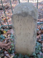
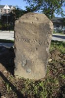
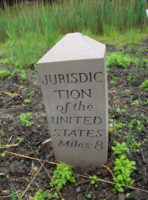
1220 Wilkes Street, Alexandria, Virginia 1220 Wilkes Street: SE corner of the intersection of Wilkes and S. Payne Streets in Alexandria, Virginia. Around 1904, the stone was moved 225 feet from its original position. When it was reset in the ground, it was rotated such that the sides of the stone marked “Virginia” and “Jurisdiction of the United States” no longer face their respective jurisdictions. The letters on the District face of the stone are smaller than those of the other stones and in a different script.
SW2
7 Russell Road, Alexandria, Virginia 7 Russell Road: east side of Russell Road just north of King Street. This is neither the original stone nor the original location. Baker and Woodward reported the original stone to be missing as of the late 1800s, and DAR records show that the current stone was placed at this location in 1920. The original stone was located about 0.35 northwest of this replacement. According to Woodward, the original “stone was evidently placed on the east side, and very close to, [King Street], on the eastern side of Shuter’s Hill, in a subdivision” now called Rosemont.
SW3
2932 King Street, Alexandria, Virginia 2932 King Street: north end of parking lot of the First Baptist Church, south of Scroggins Road in Alexandria, Virginia. This stone has been removed from the ground and reset in concrete. Note that the address is not 2952 King Street, as some sources state.
SW4
King Street & S. Wakefield Street, Alexandria, Virginia Adjacent to Fairlington Village at the edge of east side of King Street between S. Wakefield Street and Route 395. According to Woodward, farm plows had destroyed the top of this stone by the early 1900s. After being re-positioned when the highway was widened, the remaining portion of the stone has sunk very low into the ground.
SW5
Walter Reed Parkway & King Street, Alexandria, Virginia North side of Walter Reed Parkway 100+ feet east of intersection with King Street. Only the stump of this stone remains. Its current condition is consistent with Woodward’s 1908 report that the “stone is broken, and the top seems to be lost. The entire base, with a few inches of the finished portion, was found lying on the ground in approximately the same spot where it had originally been placed.” This stone is now nearly 45 feet from its original position.
SW6
Jefferson Street & Columbia Pike, Arlington, Virginia Median strip of Jefferson Street 0.1 miles south of Columbia Pike in Arlington, Virginia. This stone has been re-positioned several times. It also has been hit by a car and cemented back together.
SW7
5995 5th Road, Arlington, Virginia 5995 5th Road, Arlington, Virginia: Carlin Springs Elementary School, parking lot C, near the fence. It is also possible to reach this stone from the opposite direction via the private park behind the tennis courts at 3101 S. Manchester Street, Falls Church, Virginia. Follow the southeast edge of the tennis courts to the (often locked) gate to the private park.
SW8
John Marshall Drive & Wilson Boulevard, Arlington, Virginia A short distance from the intersection of John Marshall Drive and Wilson Boulevard: 100 feet southeast of water tower behind the Patrick Henry Apartments. The stone is at the edge of the parking lot across from units 6184 and 6172. As the informational sign near the stone states, this is not the original location.
SW9
Benjamin Banneker Park, Falls Church, Virginia Benjamin Banneker Park on Van Buren Street south of 18th Street in Falls Church, Virginia.
West
Andrew Ellicott Park, 2824 N. Arizona Street, Falls Church, Virginia Andrew Ellicott Park: 2824 N. Arizona Street (sometimes listed as 2824 Meridian Street), south of West Street in Falls Church, Virginia.
NW1
3607 Powhatan Street, Arlington, Virginia 3607 Powhatan Street, Arlington, Virginia, north of 36th Street: west side of back yard, 200 feet from the road.
NW2
5298 Old Dominion Drive, Arlington, Virginia 5298 Old Dominion Drive, or 5145 N. 38th Street, Arlington, Virginia: in the fence separating the back yards of two homes.
NW3
4013 N. Tazewell Street, Arlington, Virginia. 4013 N. Tazewell Street, Arlington, Virginia: back yard of home.
NW4
Dalecarlia Reservoir, Bethesda, Maryland Within the fenced Dalecarlia Water Treatment Plant grounds, 100+ feet east of the Capitol Crescent Trail (from the “Entering Montgomery County” sign) and several hundred feet north of the intersection of Norton Street NW and Potomac Avenue NW. The easiest way to see this stone is through the fence along the Crescent Trail because the treatment plant is closed to the public. It is also possible to schedule a visit to the stone during normal business hours by calling the Dalecarlia Water Treatment Plant’s main number at (202) 764-2753. Older sources list the stone’s location as 5906 Dalecarlia Place NW, but the “government dwelling” once located at that address has been demolished.
NW5
Dalecarlia Reservoir, Bethesda, Maryland 600 feet west of Dalecarlia Parkway and 300 southeast of concrete culvert, within the fenced Dalecarlia Reservoir property. From the intersection of Dalecarlia Parkway and Warren Place, walk into the forest on the west side of the Parkway. The fence around the reservoir property should be immediately visible. Follow the fence west along the northern border of the property. When the fence crosses over the creek, the concrete culvert is easily visible within the fenced area. Shortly before the crossover, there once was a person-sized hole in the fence. The stone is several hundred feet southwest of this hole and too deep into the forest to see from outside the fenced area. From the hole one could imagine reaching the stone by following an approximately straight line down the hill from the fence, across the creek (staying slightly east of the fork), and up the next hill, keeping the occasional utility markers within sight. Unfortunately, entering through the hole constitutes trespassing on federal property. Thankfully, it is possible to schedule a visit to the stone during normal business hours by calling the Dalecarlia Water Treatment Plant’s main number at (202) 764-2753.
NW6
Park and Western Avenues, Bethesda, Maryland 150 northeast of intersection of Park and Western Avenues in small park, across from intersection of Western Avenue and Fessenden Street.
NW7
5600 Western Avenue, Chevy Chase, Maryland 5600 Western Avenue: front yard of home near intersection with Cedar Parkway, McKinley Street, and 41st Street. The owners of the home removed the protective fence in the 1940s. In the mid-1960s, the stone was repositioned and a plaque was affixed directly to it.
NW8
6422 Western Avenue, Chevy Chase, Maryland 6422 Western Avenue, southwest of Pinehurst Circle: front yard of home, within circular driveway. This stone does not have a protective fence.
NW9
2701 Daniel Road, Chevy Chase, Maryland 2701 Daniel Road, Chevy Chase, Maryland: 165 feet northwest of the center line of Daniel Road and 5 feet southeast from the edge of the driveway. Near the intersection of Western and Oregon Avenues next to Rock Creek Park.
North
Near 1850-1806 East-West Highway, Silver Spring, Maryland Immediately south of East-West Highway in the edge of the forest just west of the townhouses at Chevy Chase Crest condominium community, near 1850 1806 East-West Highway. Please note that the marker in the traffic circle where 16th Street, Eastern Avenue, and Colesville Road intersect, more than a quarter of a mile to the east, is not a District of Columbia boundary stone.
NE1

7847 Eastern Avenue, Silver Spring, Maryland 7847 Eastern Avenue, northwest of intersection with Georgia Avenue: bronze plaque in place of stone in the sidewalk in front of a shop. The stone was accidentally bulldozed and removed during the construction of the storefront in September 1952. A replica stone was created in 2015 but has not yet been placed.
NE2
6980 Maple Avenue, Takoma Park, Maryland 6980 Maple Avenue, Takoma Park, Maryland: front yard of home near intersection of Maple and Carroll Avenues.
NE3
Eastern Avenue & Chillum Road, Takoma Park, Maryland 144 feet northwest of intersection of Eastern Avenue and Chillum Road at the edge of a commercial parking on the Maryland side of Eastern Avenue, just south of New Hampshire Avenue.
NE4
5400 Sargent Road, Hyattsville, Maryland 5400 Sargent Road: side yard of home on Maryland side of Eastern Avenue just north of Sargent Road.
NE5
4609 Eastern Avenue, Mount Rainier, Maryland 4609 Eastern Avenue, northwest of Varnum Street: front yard of home.
NE6
3601 Eastern Avenue, Mount Rainier, Maryland 3601 Eastern Avenue, near intersection with 34th Street: front yard of home. This stone has been reset in concrete.
NE7
Fort Lincoln Cemetery, Brentwood, Maryland Fort Lincoln Cemetery: along the fence in Block 18, 75 feet southwest of Garden Mausoleum near Garden of the Crucifixion.
NE8
Eastern and Kenilworth Avenues, Capitol Heights, Maryland Along the fence 500 feet northwest of the intersection of Eastern and Kenilworth Avenues. Until 2013, there were three trails that led to the stone. Because the area is now under development, these trails may not be as easy to follow as they once were. 1) From the intersection of Eastern and Kenilworth, follow the trail that begins at a separation in the fence along the north side of Kenilworth. The trail immediately winds to the right where it follows another fence northwest along the edge of a gravel distribution lot. The trail forks when the gravel lot fence begins to turn to the right; turn left here. The left fork roughly parallels another fence and leads to the charred rubble of a former dwelling. The stone is along the fence to the right, about 50 feet before you reach the remains of the dwelling. View route. 2) From the intersection of Eastern and Kenilworth, head southwest on Kenilworth and turn right on Quarles Road. Turn right again, before reaching 45th Street, onto a road leading to a smokestack across the street from an apartment complex. As Kanon explained in Stoned Out of My Mind: A Guide to and Personal Reflections of the Boundary Stones for the District of Columbia, “Just E of parking lot, look for a hole in the black fence. Follow a trail for about 300 ft. to another fence. Near a pool of water.” 3) From the intersection of Eastern and Kenilworth, head southwest on Kenilworth and turn right on Quarles Road. Turn right again when Quarles ends at Anacostia Avenue. Anacostia ends shortly thereafter at a forest, where a trail leads past the former dwelling to the stone.
NE9
919 Eastern Avenue, Fairmount Heights, Maryland 919 Eastern Avenue, 0.1 miles south of Sheriff Road: front yard of home.
East
Eastern Avenue and Southern Avenue, Capitol Heights, Maryland 100 feet southeast of the intersection of Eastern Avenue and Southern Avenue.
SE1
D Street & Southern Avenue, Capitol Heights, Maryland 30 feet south of intersection of D Street and Southern Avenue, near corner of wall around National Capitol Hebrew Cemetery.
SE2
4345 Southern Avenue, Capitol Heights, Maryland 4345 Southern Avenue, near intersection with Rail Street: front yard of home. Note that this is not 4245 Southern Avenue, as some sources state.
SE3
3908 Southern Avenue, Suitland, Maryland Across the street from 3908 Southern Avenue, near Suitland Terrace. SE3 is unusually tall for an intermediate stone. Woodward, observing that the west corner stone is much shorter than the other corner stones, hypothesized that there was a mixup between the tall stone that became SE3 and the short stone that became the West stone.
SE4
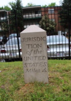
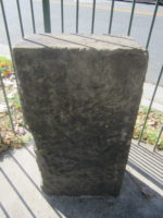
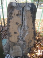
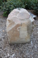
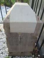
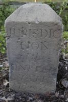
3101 Southern Avenue, Temple Hills, Maryland 3101 Southern Avenue SE: along the gate in front of the parking lot, just south of the merger with Naylor Road (and not at the intersection of Naylor Road and Suitland Parkway, as some earlier sources state). This stone is a replica created in 2015 and placed in early 2016 about twenty yards southwest of its original location. By the time of Woodward’s visit more than a century ago, the original stone was “rounded, battered and chipped on every side” possibly because “soldiers used it as a target” during the Civil War. When a truck knocked the stone out of place in 1985, the manager of a nearby apartment building moved it into the building’s boiler room for safekeeping. In 1991, the building manager gave the stone to the bicentennial resurveying team, who, in 2012, transferred the stone to the D.C. Office of the Surveyor, where it remains on display (shown below).
SE5
Southern Avenue Metro, Hillcrest Heights, Maryland 280 feet northeast of the northernmost intersection of Southern Avenue and Valley Terrace (the roads intersect twice within a quarter mile). This stone is next to the sidewalk along Southern Avenue in front of the Southern Avenue metro station.
SE6
901 Southern Avenue, Oxon Hill, Maryland 901 Southern Avenue. Until early 2008, this was one of the best-looking stones. Then an out-of-control car broke the stone in half at ground level and destroyed the protective fence. During 2012 through 2014, the above-ground portion of the stone was stored in the D.C. Office of the Surveyor for safekeeping. The stone and a protective fence are again in place.
SE7
Southern Avenue & Indian Head Road, Oxon Hill, Maryland 25 feet south of intersection of Southern Avenue and Indian Head Road on the east side of Indian Head Highway. This stone has been re-positioned. Note that the National Register of Historic Places incorrectly states that the stone is northeast of the intersection.
SE8
Behind Blue Plains Impound Lot, Forest Heights, Maryland Behind Blue Plains Impound Lot: southeast corner of the lot on the Maryland side of the fence, a short distance from the lightposts. This is a replica stone created in 2015 and placed in early 2016. The most direct way to reach the location is to take Oxon Hill Farm Trail south from D.C. Village and then, after crossing the border into Maryland, follow the access road along the chain link fence west until you reach the back of the impound lot. The direct walking route will almost certainly take you through some very swampy territory, however. A cleaner and easier route is to take the Oxon Hill Farm Trail south from D.C. Village, and then, before crossing the bridge over Oxon Creek, follow the unpaved path to the right southwest along the creek to the large clearing with overhead power lines. Follow the clearing northwest to the fence along the Maryland border and then walk a short distance southwest along the fence to the corner of the impound lot. The original stone was removed in 1958 during construction and then either lost or stolen from a storage facility before it could be reset in the ground. On March 23, 1962, DAR placed a new inscription-less stone in the same location along with the original stone’s iron fence. By 1972, this stone too was in trouble, as described by Edwin Darby Nye in a paper read that year before the Columbia Historical Society: “SE8, at the far end of the D.C. Village Area, has become a victim of a large land-fill operation, involving the D.C. auto impounding area, the new sewage treatment plant, and an eighteen-hole golf course being constructed by the National Park Service. SE8 is covered with some eight feet of landfill. A sixty-inch concrete pipe has been placed over the stone, iron fencing and all, and a cover placed over it to protect it. The stone has been uncovered and after excavation has been completed it will be reset in a proper location.” Unfortunately, nothing of the sort occurred, and the substitute stone was completely covered by landfill until 1991 when the bicentennial resurveying team dug it out of the ground, using old photos to approximate its location. The team then decided that the best way to preserve the stone was to put it back underground (photo below), this time protected by a taller pipe that was visible above the surface. The substitute stone was removed in 2015 and replaced the next year with a replica of the original, now at ground level.
SE9
I-295 Oxon Cove Bridge, Oxon Hill, Maryland About 1000 feet southwest of the southern end of Oxon Cove Bridge and about 200 feet east of the Potomac River. Oxon Cove Bridge is the bridge that I-295 crosses just north of the intersection with I-495. You can reach this stone on foot by following the partially-paved path that leads to Oxon Hill Farm from either D.C. Village Lane in Washington or the intersection of Oxon Run Drive and Audrey Lane in Maryland. Leave the path when it turns away from Oxon Cove; then follow the Oxon Cove shoreline to the base of Oxon Cove Bridge, where you must cross underneath I-295 to get to the Potomac River. From the endpoint of the large rocks that surround the base of the bridge, follow the Potomac shoreline about 1,000 feet southwest until you are just past due west of the Masonic Memorial (across the river) and the bridge is no longer visible behind you. If you are on a small sandy beach with car tires and debris, you are in the right place. The stone is about 200 feet to the east. View the walking route from Audrey Lane. The terrain along this route is marshy and occasionally rough, so it may be much simpler to access the stone by car. Park on the right shoulder of the southbound lanes of I-295 near the “Maryland Welcomes You” sign and walk west into the forest to a fence. Follow the fence several dozen feet north to reach a small hole. Enter the hole and walk west through the forest. Depending on your route, you may cross an empty field that once was a staging area for the construction of the highway. Continue west to a very steep hill (actually an earthen dam created to protect the highway from flooding), and walk north, keeping on the east side of the hill, for a short distance. As documented by Woodward, this stone once was next to the Potomac River at Fox Ferry Point, the terminus of an 1800s ferry line from the foot of King Street in Alexandria to Maryland. In the early 1950s, 1969, and 2016, the stone was moved northeast of Fox Ferry Point to save it from being damaged by the river. The National Register of Historic Places incorrectly states that the stone is east of Shepherd Parkway, when, in fact, it is west and nearly a mile south of the end of Shepherd Parkway.