Early History
The Residence Act of July 16, 1790, as amended March 3, 1791, authorized President George Washington to select a 100-square-mile site for the national capital on the Potomac River between Alexandria, Virginia, and Williamsport, Maryland. President Washington selected the southernmost location within these limits so that the capital would include all of present-day Old Town Alexandria, then one of the busiest ports in the country. Acting on instructions from Secretary of State Thomas Jefferson, Major Andrew Ellicott began his initial observations for a rough survey of the ten-mile square on Friday, February 11, 1791.
Ellicott, a prominent professional surveyor, hired Benjamin Banneker, an astronomer and surveyor from Maryland, to make the astronomical observations and calculations necessary to establish the south corner of the square at Jones Point in Alexandria. According to legend, “Banneker fixed the position of the first stone by lying on his back to find the exact starting point for the survey … and plotting six stars as they crossed his spot at a particular time of night.” From there, Ellicott’s team embarked on a forty-mile journey, surveying ten-mile lines first along the southwest line, then along The northwest line, next along the northeast line, and finally along the southeast line. The team completed this rough survey in April 1791.
On April 15, 1791, the Alexandria Masonic Lodge placed a small stone at the south corner at Jones Point in ceremonies attended by Ellicott, federal district commissioners Daniel Carroll and David Stuart, and other dignitaries. George Washington did not attend the ceremony, although he did visit the site the prior month. Newpapers around the country announced the story of the beginning of the new federal city. (In 1794, the ceremonial stone at Jones Point was replaced by a large stone, still in place today, with the inscription “The beginning of the Territory of Columbia” on one side.)
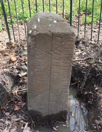
Ellicott’s team, minus Banneker, who left after the placement of the south stone, then began the formal survey by clearing twenty feet of land on both sides of each boundary line and placing other stones, made of Aquia Creek sandstone, at one-mile intervals. On each stone, the side facing the District of Columbia displayed the inscription “Jurisdiction of the United States” and a mile number. The opposite side said either “Virginia” or “Maryland,” as appropriate. The third and fourth sides displayed the year in which the stone was placed (1791 for the 14 Virginia stones and 1792 for the 26 Maryland stones) and the magnetic compass variance at that place. Stones along the northwest Maryland boundary also displayed the number of miles they fell from NW4, the first stone placed in Maryland. Stones placed at intervals of more than a mile included that extra distance measured in poles.
The boundary stones are the oldest federal monuments. Although several stones have been moved or severely damaged, thirty-six stones from the 1790s are in or near their original locations, including all fourteen in the land that was returned to Virginia in the 1846-1847 retrocession. Three other locations have substitute stones (SW2, SE4, and SE8), and one location (NE1) is marked only by a plaque. This site describes the locations of the stones as of 2016, updating the information provided by the Daughters of the American Revolution (1976) and the National Register of Historic Places (1996).
Growing Public Interest
After Ellicott’s team, the next to survey the stones was Marcus Baker, who visited each stone’s location during the summer of 1894. Baker reported his survey to the Columbia Historical Society. Following Baker, Fred E. Woodward photographed thirty-nine of the boundary stones–all but SW2, which had been lost even before Baker’s survey–starting in 1905. In his reports to the Columbia Historical Society (published in 1907, 1908, and 1915) and in public presentations, Woodward described the extent to which the stones had deteriorated and proposed that they be protected for the enjoyment of future generations. Ernest A. Shuster, Jr., followed in Woodwards’s footsteps soon after with his own impressive photo collection and article.
In 1915, the Washington, D.C., chapter of the Daughters of the American Revolution (DAR), citing Woodward’s work, voluntarily assumed the responsibility of protecting the stones by erecting a tall iron fence around each one. For decades afterward, DAR members visited the stones periodically to perform routine maintenance. Despite DAR’s care and attention, however, many of the stones fell on hard times during the mid-1900s. Several were re-positioned, removed, lost, or buried during construction projects.
Subsequent Restoration Efforts
In 1978, Kevin Wood of Boy Scout Troop 98 led a service project that visited most of the stones to clean up the sites and repaint the fences. As Mr. Wood explained in 2012,
“It was a fun project which we did over three or four days, All the Virginia ones one day, All Anacostia another. And I am pretty sure we did the top half of the city over two days. The green paint came from the DC parks department; my dad called them and set it up. An older parks employee came by the house one day with the paint and he and I drove around the city, to show me where the stones were. He seemed to be pretty enthusiastic about it, he showed me Southeast 9 and the one in Kenilworth Gardens. I am pretty sure he even took me across the bridge to the one at the southern tip of DC, but not the VA ones. So we sort of had permission to do the ones in DC. In VA we hadn’t contacted anybody. If the stone was in a public place or a park, VA fences got a coat of green DC paint too. In some cases the stones, in VA, DC and MD were on lawns and cared for and we didn’t do anything. We always rang the doorbells and talked to the people and asked if they wanted us to paint the fences. I think they always or almost always said no. Usually they had them painted black. Sometimes we clipped the weeds ad the hedges on private property, I think we did this for one on Eastern Avenue inside of a chan link fence surrounded by hedges. The only stone we didn’t actually get to see was one in a backyard in VA, the first or second on the northern stretch. The woman of the house was very firm about not allowing us to see it.”
In 1990 and 1991, a resurveying team led by David Doyle to celebrate the District’s bicentennial located two missing stones. In September 1995, the Northern Virginia Boundary Stones Committee (NOVABOSTCO), under the leadership of chairman Ric Terman, issued a 77-page report on the status of the fourteen stones in Virginia. NOVABOSTCO’s successor, the Nation’s Capital Boundary Stones Committee (NACABOSTCO), co-chaired by Terman and Stephen Powers, has worked since 2000 to ensure the preservation and appreciation of all of the stones, partnering with DAR, the American Society of Civil Engineers – National Capital Section (ASCE-NCS), the District of Columbia Association of Land Surveyers, and other government agencies, historical societies, and professional associations.
Boundarystones.org was created in April 2006. Since 2010, ASCE-NCS has led biannual restoration projects that pick up where Troop 98 left off. In 2014 and 2015, DAR renewed its efforts to preserve the stones. In 2015 and 2016, the District Department of Transportation and National Park Service worked together to protect the east and north corner stones and place replica stones for SE4 and SE8. For the first time since since the 1970s, all stone locations have visible markers.